


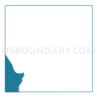
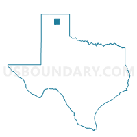
Voting District 0021, Hutchinson County, Texas
About
Outline

Summary
| Unique Area Identifier | 674946 |
| Name | Voting District 0021 |
| County | Hutchinson County |
| State | Texas |
| Area (square miles) | 47.30 |
| Land Area (square miles) | 40.38 |
| Water Area (square miles) | 6.92 |
| % of Land Area | 85.37 |
| % of Water Area | 14.63 |
| Latitude of the Internal Point | 35.66221140 |
| Longtitude of the Internal Point | -101.61166890 |
Maps

Graphs
Select a template below for downloading or customizing gragh for Voting District 0021, Hutchinson County, Texas


Neighbors
Neighoring Voting District (by Name) Neighboring Voting District on the Map
- Voting District 0023, Hutchinson County, TX
- Voting District 0031, Hutchinson County, TX
- Voting District 0033, Hutchinson County, TX
- Voting District 0201, Moore County, TX
- Voting District 0203, Moore County, TX
- Voting District 0302, Carson County, TX
Top 10 Neighboring County Subdivision (by Population) Neighboring County Subdivision on the Map
- Dumas CCD, Moore County, TX (19,812)
- Borger CCD, Hutchinson County, TX (19,341)
- Panhandle CCD, Carson County, TX (3,795)
- Stinnett CCD, Hutchinson County, TX (2,809)
- Sunray CCD, Moore County, TX (2,092)
Top 10 Neighboring Place (by Population) Neighboring Place on the Map
Top 10 Neighboring Unified School District (by Population) Neighboring Unified School District on the Map
- Dumas Independent School District, TX (19,719)
- Borger Independent School District, TX (14,493)
- Sanford-Fritch Independent School District, TX (5,111)
- Panhandle Independent School District, TX (3,465)
- Plemons-Stinnett-Phillips Consolidated Independent School District, TX (2,678)
Top 10 Neighboring State Legislative District Lower Chamber (by Population) Neighboring State Legislative District Lower Chamber on the Map
Top 10 Neighboring State Legislative District Upper Chamber (by Population) Neighboring State Legislative District Upper Chamber on the Map
Top 10 Neighboring 111th Congressional District (by Population) Neighboring 111th Congressional District on the Map
Top 10 Neighboring Census Tract (by Population) Neighboring Census Tract on the Map
- Census Tract 9502, Moore County, TX (6,671)
- Census Tract 9505, Hutchinson County, TX (4,913)
- Census Tract 9502, Carson County, TX (3,795)
- Census Tract 9502, Hutchinson County, TX (2,809)
- Census Tract 9501, Moore County, TX (2,092)